UPDATES
March 2019
We continue to build up our map of the levels of radioactive cesium along the west coast of North America (Figure 1). With the help of citizen scientists around the Pacific as well as through efforts on oceanographic research cruises we have found little change in 2018 over prior years, with some exceptions in coastal sites with a few samples being more elevated, and the trend still increasing in general (see Figure 2). Thanks to our citizen scientists and supporters, we hope to continue monitoring in the Pacific to understand the full consequences of the unprecedented releases and observe the return to pre-2011 conditions.
Read more

Figure 1. Levels of cesium-137 in water samples taken near the surface ocean between 2011 and 2018. All samples shown contain some pre-Fukushima cesium-137 due to nuclear weapons testing which in the region shown, is less than 2.0 Becquerels per cubic meter (Bq/m3 - light blue circles). Other colors indicate evidence of Fukushima-derived cesium at varying levels (Yellow = 2.0-3.9 Bq/m3; Orange = 4.0-7.9 Bq/m3; Brown = >8.0 Bq/m3).

Figure 2. Time history of cesium-137 vs. time, combining all coastal stations. The trend in general is for increasing cesium at all sites through 2018. The higher values in 2015 in Ucluelet BC, and a few elevated samples found in Bodega Head and San Luis Obispo in late 2017/early 2018, are transient events, most likely related to mixing of off shore waters, which are higher in cesium (see Figure 1) with coastal waters.
It is important to know that prior to 2011, there was already cesium-137 in the ocean remaining from atmospheric nuclear weapons testing that peaked in the 1960’s. Today, levels above 2.0 Becquerels per cubic meter (Bq/m3) in the surface ocean, indicate additional cesium from the Japanese releases. As noted last year, what we find along the west coast, while definitely showing an increase in cesium from the 2011 accident, the levels are still well below regulatory limits of 7,400 Bq/m3 set for drinking water (U.S. EPA). By our calculations, even if levels increase to 10 Bq/m3, swimming eight hours every day for an entire year, would only increase one’s annual dose by an amount, 1000 times less than a single dental X-ray.
Canadian researchers measuring cesium-137 in fish, are finding similarly low levels relative to regulatory thresholds in seafood, such as salmon. Taken together with ORO results, this provides important information about the transport of radioactive contaminants across the Pacific, along our coastlines, and through the food chain.
For a recent scientific publication linking the near shore and off shore cesium results in the context of oceanographic processes, see J. N. Smith et al., Environmental Science and Technology, 2017.
March 2018
Since March 2011, when a tsunami damaged the Fukushima Dai-ichi Nuclear Power Plant in Japan, we have documented the ongoing release of radioactive isotopes of cesium into the Pacific. We have focused on cesium is because it was one of the most abundant radioactive contaminants released, and some forms of it can remain in the environment for decades. Over the last seven years, with the help of citizen scientists around the Pacific as well as through research cruises and field expeditions, we have been able to track the spread of this element across the ocean and now along the western U,S, and Canadian coastlines.
Read more

Figure 1. Levels of cesium-137 in water samples taken near the ocean surface between 2011 and 2017. All samples shown contain some pre-Fukushima detectable cesium-137 due to nuclear weapons testing (white circles) which in the region shown is less than 2.0 Bq/m3. Colored circles indicate evidence of Fukushima-derived cesium at varying levels, as indicated by color (Yellow = 2.0-3.9 Bq/m3; Orange = 4.0-7.9 Bq/m3; Brown = >8.0 Bq/m3).
It is important to note that, prior to these events in 2011, there was already measurable amounts of radioactive fallout in the ocean left over from the testing of nuclear weapons that peaked in the 1960’s. For cesium-137, levels in Pacific Ocean surface waters were generally below 2.0 Becquerels per cubic meter (Bq/m3).1 We now see cesium-137 levels above this level at locations along coastlines in California, Oregon, Washington, British Colombia ,and Hawaii, as well as higher levels offshore (Figure 1). This increase, as well as our finding of cesium-134 in these elevated samples, provides clear evidence that Fukushima contamination has reached our shores.

Figure 2. Updated cesium-137 versus sampling time at three U.S. coastal locations. The solid line indicates the linear trend over time and indicates increases at all four sites.
Our most recent coastal sample collected in Bodega Bay, Calif., in 2017, showed 7.2 Bq/m3 of cesium-137, with other sites showing 4.8±0.1 Bq/m3 (Hawaii), 4.4±0.2 Bq/m3 (Mulkiteo, Wash.), and 6.4±0.2 Bq/m3 (Eureka, Calif.). In these site and elsewhere, the trend continues upward (Figure 2), with slightly higher levels found offshore. While elevated, these levels are still well below regulatory limits of 7,400 Bq/m3 set for drinking water (U.S. EPA). By our calculations, even if levels increase Bq/m3, swimming eight hours every day for an entire year would only increase one’s annual dose by an amount, 1000 times less than a single dental X-ray. Canadian researchers measuring cesium-137 in fish, are finding similarly low levels relative to regulatory thresholds in seafood, such as salmon. While low, this provides important information about the transport of radioactive contaminants across the Pacific, along our coastlines, and through the food chain.
We hope to continue monitoring changes along the western North America coast to understand the full impact and to document the eventual return to pre-2011 conditions. Our thanks again, to all the citizens who, through their sampling efforts and financial support, have supported this important monitoring effort!
1One Bq = one disintegration per second; and one m3 is equivalent to about 264 gallons.
March 2017
It has now been six years since the March 2011 tsunami off Japan damaged the Fukushima Dai-ichi Nuclear Power Plant and resulted in unprecedented releases of cesium-134, cesium-137, and many other gaseous and volatile radioactive elements to the Pacific Ocean. From the early days of the disaster, we have tracked the spread of these radioactive contaminants throughout the ocean and east towards North America. Since 2013, with the continuous support and sampling by citizen scientists with Our Radioactive Ocean (ORO), we have monitored the waters off the West and, in 2015 and 2016, samples collected by ORO volunteers showed the arrival and spread of contamination directly linked to Fukushima on this side of the Pacific.
Read more
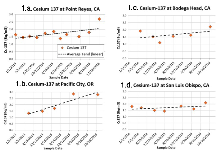
Figure 1. Cesium-137 vs. sampling time at 4 U.S. coastal locations. Dashed line is the linear trend showing small increases due to arrival of cesium from Fukushima. These levels are thousands of times lower than U.S, drinking water limits and lower than equivalent values in the ocean in the 1950s and 60s caused by nuclear weapons testing in the Pacific.
Our work does not end with that discovery, however. TEPCO, the utility company that operated the plant and continues to oversee the cleanup effort, recently found the highest radiation levels to date (530 Sieverts) in Reactor 2, the one most heavily damaged by an explosion after the tsunami (see Washington Post article here). It is important to note that these measurements were the first to be made inside the primary containment vessel of Reactor 2, where radiation levels were expected to be high as a result of nuclear fuel being stored there.
Although the long-term storage and removal of this material is of obvious concern, there is currently no evidence that this radiation is leaking from Reactor 2 into the surrounding air or water, but we continue to watch for signs that this might occur. For example, on our most recent cruise to Japan in November 2016 we found elevated cesium, but at levels no higher than what we saw in recent years. This means that the tons of water escaping the site remain contaminated, but at levels thousands of times lower than what we saw at the beginning of the accident. Given that the contamination has not lessened and still exists on-site, monitoring and remediation efforts need to continue throughout the decades-long decommissioning process to ensure that further releases do not occur.
Until recently we have been using cesium-134 as a “fingerprint” of Fukushima in the Pacific. Because this isotope has only a two-year half-life and because we know of no other significant sources of it to the ocean, any amount we find must have come from Fukushima. After six years—three half-lives of the isotope—the amount of cesium-134 in the ocean has decayed to approximately 12% of the original amount released. This makes what was already in low concentration even more difficult to detect. Instead, we are now looking at the trend of increasing cesium-137 found along the West Coast as a more reliable signal indicating the presence of contamination from Fukushima.
Our highest levels to date of cesium in coastal waters have been found near Pacific City, Oregon, with total cesium-137 levels between 2.8 and 3.2 Becquerels per cubic meter (Bq/m3) (Fig. 1a). Pre-Fukushima levels of cesium-137 along the coast were generally below 2 Bq/m3, mostly the result of nuclear weapons testing in the Pacific.
Continuous monitoring at several sites (Point Reyes, Figure 1a; Pacific City, 1b; Bodega Head, 1c; and San Luis Obispo, 1d) has allowed us to identify a clear trend in the increase of cesium-137 over the past three years that also appears when we plot results from all coastal sampling sites. However, we do not have complete time series at many other sites, so we have compiled a map to indicate where we have seen the telltale sign of cesium-134 from Fukushima in prior sampling, both along the coast and further offshore (Figure 2).
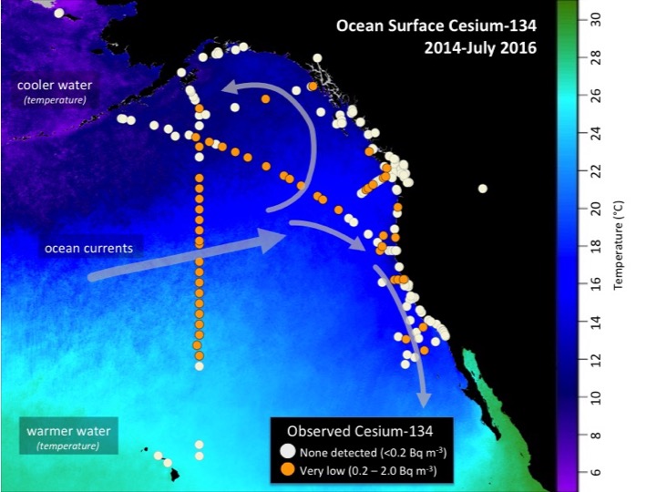
Figure 2. Map showing locations of samples with measurable cesium-134 (orange circles) carried by ocean currents from Fukushima. All samples have detectable cesium-137 as a result of atmospheric nuclear weapons testing in the 1950s and 60s. All data available at OurRadioactiveOcean.org (updated July 2016).
It is important to note that the levels we see are still extremely low, more than 500 times below both the U.S. drinking water standard and any level thought to pose a harm to marine life or to humans as a result of swimming or other contact with sea water. We don’t expect these levels to get much higher, but until they start to decrease, we will not know what peak levels will be along West Coast beaches.
Finally, we published an open-access review of Fukushima and its impact on the ocean (available here) in January 2017 that includes data from our sampling efforts to look at the spread of cesium across the Pacific to the West Coast. It also covers the changing levels of Fukushima contaminants in marine biota as well as the potential health effects and societal impacts of these releases.
As we begin to see higher levels of cesium along the West Coast of North America and concerns continue to arise in the media and elsewhere, it becomes even more vital that we continue our monitoring efforts. We still need to determine the timing and magnitude of peak levels relative to releases from Fukushima, for example. It is also important that we continue provide the public with unbiased information about the impact of Fukushima on the ocean. We want to thank the hundreds of donors and citizen scientists who have made this possible and hope to continue our efforts into 2018 and beyond.
December 3, 2015
Perhaps the biggest news of 2015 is that we have begun seeing more sites, especially offshore where we have expanded our sampling, with contamination directly linked to Fukushima. These data are important for two reasons: First, they indicate that, despite the presence of these radioactive isotopes, the levels of contamination remain well below government-established safety limits for human health or to marine life. Second, these long-lived radioisotopes will serve as markers for years to come for scientists studying ocean currents and mixing in coastal and offshore waters.
Read more
Before we get into the details of what we are finding, it's important to reiterate that almost any seawater sample from the Pacific will show traces of cesium-137, an isotope of cesium with a 30-year half-life, some of which is left over from nuclear weapons testing carried out in the 1950s to 1970s. The isotope cesium-134 is the "fingerprint" of Fukushima, but it decays much quicker (it has a 2-year half-life). When we find traces of cesium-134, we back-calculate from the amount we detected to determine how much was actually released from Fukushima in 2011. An equal amount of cesium-137 would have been released with it at the same time.
Our highest detection level to date came from a sample collected about 1,600 miles west of San Francisco that contained 11 Becquerels per cubic meter of cesium-137 and cesium-134. This means that in one cubic meter of seawater (about 264 gallons), 11 radioactive decay events per second can be attributed to cesium atoms of both isotopes. That is 50 percent higher than we’ve seen before, but even these levels are still more than 500 times lower than safety limits established by the US government for drinking water and well below limits of concern for direct exposure while swimming, boating, or other recreational activities. Our findings agree with those reported by the scientists who are part of the group Kelp Watch and by the team of Canadian scientists working under the INFORM umbrella.
We have presented data from Our Radioactive Ocean in public talks throughout the year, many of which are online, and this will continue with a talk at the San Francisco AGU meeting on December 14, the largest gathering of earth and space scientists in the world. Earlier this year, we produced a new brochure that takes a simple, accessible look at radiation and its impacts on the environment and on humans. You can download it here. We also continued to independently monitor the ongoing leaks from Fukushima Dai-ichi by sampling, as recently as this October, with our Japanese collaborators as close as one kilometer off the nuclear power plants.
There is always more to do, and to this end we are working on several projects as we head to 2016. First, we are making some changes to the web site to improve usability. We’ve kept all data on the ORO results map (above), but now have a link just below it that takes you to a data visualization tool that gives visitors the ability to access and compare, data from Our Radioactive Ocean citizen scientists, as well as from earlier WHOI cruises off the coast of Japan, and we hope to add data gathered by our collaborators in Canada and Japan in the future.
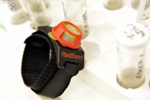
Second, we are moving ahead with development of the RadBand, a wearable device that gives any swimmer or surfer a chance to gather scientific data about the level of radioactive elements in the ocean just by going in the water. As results are shared and our user base grows, every person becomes a valuable data point as we expand the concept to other measurements of ocean properties.
As we look back on 2015, we want to thank LUSH Cosmetics, Woods Hole Sea Grant, and the Pacific Blue Foundation who helped us expand our offshore sampling off California, and the more than 500 donors that have contributed to ORO in the past two years. With levels now increasing, there is more to do in 2016, and if there is anything our collective efforts underscore, it is the need to more closely monitor contamination levels across the Pacific.
November 10, 2014: Fukushima Radioactivity Detected Off West Coast
Monitoring efforts along the Pacific Coast of the U.S. and Canada have detected the presence of small amounts of radioactivity from the 2011 Fukushima Dai-ichi Nuclear Power Plant accident 100 miles (150 km) due west of Eureka, California. Scientists at the Woods Hole Oceanographic Institution (WHOI) found the trace amounts of telltale radioactive compounds as part of their ongoing monitoring of natural and human sources of radioactivity in the ocean.
Read more
In the aftermath of the 2011 tsunami off Japan, the Fukushima Dai-ichi Nuclear Power Plant released cesium-134 and other radioactive elements into the ocean at unprecedented levels. Since then, the radioactive plume has traveled west across the Pacific, propelled largely by ocean currents and being diluted along the way. At their highest near the damaged nuclear power plant in 2011, radioactivity levels peaked at more than 10 million times the levels recently detected near North America.
“We detected cesium-134, a contaminant from Fukushima, off the northern California coast. The levels are only detectable by sophisticated equipment able to discern minute quantities of radioactivity,” said Ken Buesseler, a WHOI marine chemist, who is leading the monitoring effort. “Most people don’t realize that there was already cesium in Pacific waters prior to Fukushima, but only the cesium-137 isotope. Cesium-137 undergoes radioactive decay with a 30-year half-life and was introduced to the environment during atmospheric weapons testing in the 1950s and ‘60s. Along with cesium-137, we detected cesium-134 – which also does not occur naturally in the environment and has a half-life of just two years. Therefore the only source of this cesium-134 in the Pacific today is from Fukushima. ”
The amount of cesium-134 reported in these new offshore data is less than 2 Becquerels per cubic meter (the number of decay events per second per 260 gallons of water). This Fukushima-derived cesium is far below where one might expect any measurable risk to human health or marine life, according to international health agencies. And it is more than 1000 times lower than acceptable limits in drinking water set by US EPA.
Scientists have used models to predict when and how much cesium-134 from Fukushima would appear off shore of Alaska and the coast of Canada. They forecast that detectable amounts will move south along the coast of North America and eventually back towards Hawaii, but models differ greatly on when and how much would be found.
“We don’t know exactly when the Fukushima isotopes will be detectable closer to shore because the mixing of offshore surface waters and coastal waters is hard to predict. Mixing is hindered by coastal currents and near-shore upwelling of colder deep water,” said Buesseler. “We stand to learn more from samples taken this winter when there is generally less upwelling, and exchange between coastal and offshore waters maybe enhanced.”
Because no U.S. federal agency is currently funding monitoring of ocean radioactivity in coastal waters, Buesseler launched a crowd-funded, citizen-science program to engage the public in gathering samples and to provide up-to-date scientific data on the levels of cesium isotopes along the west coast of North America and Hawaii. Since January 2014, when Buesseler launched the program, individuals and groups have collected more than 50 seawater samples and raised funds to have them analyzed. The results of samples collected from Alaska to San Diego and on the North Shore of Hawaii are posted on the website. To date, all of the coastal samples tested in Buesseler’s lab have shown no sign of cesium-134 from Fukushima (all are less than their detection limit of 0.2 Becquerel per cubic meter).
The offshore radioactivity reported this week came from water samples collected and sent to Buesseler’s lab for analysis in August by a group of volunteers on the research vessel Point Sur sailing betweenDutch Harbor, Alaska, and Eureka, California. These results confirm prior data described at a scientific meeting in Honolulu in Feb. 2014 by John Smith, a scientist at Fisheries and Oceans Canada in Dartmouth, Nova Scotia, who found similar levels on earlier research cruises off shore of Canada. Buesseler and Smith are now working together on a new project, led by Jay Cullen at the University of Victoria, Canada, called InFORM that involves Canadian academic, government and NGO partners to determine and communicate the environmental risks posed by Fukushima for Canada’s Pacific and Arctic coasts and their inhabitants.
Buesseler believes the spread of radioactivity across the Pacific is an evolving situation that demands careful, consistent monitoring of the sort conducted from the Point Sur.
“Crowd-sourced funding continues to be an important way to engage the public and reveal what is going on near the coast. But ocean scientists need to do more work offshore to understand how ocean currents will be transporting cesium on shore. The models predict cesium levels to increase over the next two to three years, but do a poor job describing how much more dilution will take place and where those waters will reach the shore line first,” said Buesseler. “So we need both citizen scientists to keep up the coastal monitoring network, but also research vessels and comprehensive studies offshore like this one, that are too expensive for the average citizen to support,” said Buesseler.
Buesseler will be presenting his results on Nov. 13, 2014, at the SETAC conference in Vancouver. He is also responding to questions from the public on the “Ask Me Anything” forum on Reddit at 1 p.m. EST on Nov. 10.
August 14, 2014
Using the most sensitive methods to measure your water samples, we have detected only cesium-137, the “legacy” cesium that remains from 1960s atmospheric weapons testing. This isotope is still in all ocean basins because of its relatively long 30-year half-life, which means it takes a long time to decay away. Levels of cesium-137 in all 43 samples analyzed thus far average 1.5 Becquerels per cubic meter of water, which is equivalent to one-and-a-half decay events per second per metric ton of water. This is a very small number if we compare it to the 7,400 Bq/m3 used by US EPA as the drinking water limit, and the millions of Bq/m3 of cesium detected in the ocean off Japan in 2011 at the peak of the accident, which at that level are of considerable concern for direct negative impacts on marine biota and human health.
Read more
The Fukushima reactors also released cesium-134 into the ocean and because it has a shorter half-life (2 years) any cesium-134 detected in the ocean today must have come from Fukushima. Though we do detect this isotope in abundance off Japan, cesium-134 is not YET present in any of the sample collected by citizen scientists along the North American west coast and Hawaii. Our instruments are capable of detecting as little as 0.2 Bq/m3 so the concentration of cesium-134 is below this level.
We emphasize that cesium-134 has not been detected “YET” as it has been detected offshore of North America by Canadian oceanographers. It’s difficult to predict when these radionuclides will arrive onshore because the mixing of offshore and onshore waters is complicated, and not represented in the simple models that predicted the arrival onshore of Fukushima radionuclides this year. The uncertainty in the predictions by these ocean models only emphasizes the importance of collecting samples from along the shores. Remember too that while those models predict increasing levels of both cesium isotopes for the next 2-3 years, the highest published prediction is for 20-30 Bq/m3, or well below what is thought to be of human health or fisheries concern. But it’s important to continue making observations with real data!
Your continued support will help us monitor how, when, and where offshore water reaches the beaches and what levels of cesium isotopes are transported by that water.
June 2, 2014
So far, none of the seawater samples taken from the Pacific Coast have contained any trace of radiation from Fukushima. They have contained the same levels of radiation that were evident in the Pacific Ocean before the Fukushima accident. These levels of cesium-137 measured at all sites are between 1 and 2 Becquerels per cubic meter, and are from the 1960s atmospheric nuclear weapons testing programs.
Read more
The lack of cesium-134, which only has a two-year half life for radioactive decay, indicates that none of the Fukushima contaminants have reached the West Coast sampling sites. Therefore, continued support for monitoring is needed as the cesium isotopes are expected to reach the coast in 2014 and levels are predicted to increase over the coming 2-3 years.
Click on a point on the map to see the data for that location.
January 28, 2014
The first results from seawater samples come from La Jolla and Point Reyes, Calif., and Grayland and Squium, Wash. Four samples from these three locations show no detectable Fukushima cesium. We know this because Fukushima released equal amounts of two isotopes of cesium: the shorter-lived cesium-134 isotope (half-life of 2 years) and the longer-lived cesium-137 (half-life of 30 years). Cesium-137 was found at levels of 1.5 Bq per cubic meter (Bq/m3), but this was already detectable prior to releases at Fukushima and came primarily from nuclear weapons testing in the Pacific during the 1950s and 1960s.
Read more
This so-called "negative" result has two immediate implications. First there should be no health concerns associated with swimming in the ocean as a result of Fukushima contaminants by themselves or as a result of any additional, low-level radioactive dose received from existing human and natural sources of radiation in the ocean (existing levels of cesium-137 are hundreds of times less than the dose provided by naturally occurring potassium-40 in seawater).
Secondly, and just as important from a scientific perspective, the results provide a key baseline from the West Coast prior to the arrival of the Fukushima plume. Models of ocean currents and cesium transport predict that the plume will arrive along the northern sections of the North American Pacific Coast (Alaska and northern British Columbia) sometime in the spring of 2014 and will arrive along the Washington, Oregon, and California coastline over the coming one to two years. The timing and pattern of dispersal underscores the need for samples further to the north, and for additional samples to be collected every few months at sites up and down the coast.
For this reason, we are also pleased to report that funds are already in hand to continue sampling at both the La Jolla and Pt. Reyes locations thanks to the foresight and generous donations of the groups who volunteered to adopt these sites. We expect levels of cesium-134 to become detectable in coming months, but the behavior of coastal currents will likely produce complex results (changing levels over time, arrival in some areas but not others) that cannot be accurately predicted by models. That is why ongoing support for long-term monitoring is so critical, now and in the future.
HOW WE ANALYZE SAMPLES AND REPORT DATA

Samples collected by scientists and citizens for Our Radioactive Ocean are analyzed in our labs at WHOI using a method that is capable of detecting extremely low levels of radioactivity produced by cesium isotopes in seawater. We report our data in units of Becquerels per cubic meter of seawater (Bq/m3), where one Bequerel is equal to one decay event per second.
Analysis
- Once we receive a sample in the lab, we first weigh it and measure the salinity of the water. Then we add a known quantity of stable cesium (Cs) to the sample (see step 4 below) and slowly pass (1 ml/min) the sample through a 5 ml column of potassium-nickel-hexacyanoferrate composite ion resin beads. This resin is specifically designed to selectively separate cesium (stable or radioactive) from the sample and has been optimized here for use in seawater samples.1
- We dry the resin and transferred it to a plastic “counting jar,” which we then place in an expensive ($75,000), high-purity germanium well detector made by Canberra Industries2 for between 24 and 72 hours (see 3:05 here). Every time a cesium atom decays, the event is registered in the instrument’s multichannel analyzer, which has the ability to discern energy given off by decay of two critical isotopes of cesium: 134Cs and 137Cs.3 By counting the decay events associated with each isotope, we calculate the total counts per second (cps) for a given sample.
- By periodically analyzing standards samples with known levels of cesium, we can calculate the detector efficiency. With this information, the sample weight, the cps, and the number of cesium gamma events per decay (the so-called “branching ratio”), we can calculate the total activity of 134Cs and 137Cs in each sample.
- By adding a known quantity of stable cesium to each sample at step 1, and then measuring how much passes through the resin column, we can determine a chemical yield for the extraction procedure. This stable cesium “yield monitor” is determined using an inductively coupled mass spectrometer. Extraction yields for the resin columns are typically 96 to 99 percent.

Accuracy
The result for each sample includes the total activity (Bq/m3) and an associated counting error, which is a measure of how precisely we can analyze for Cs isotopes: for example, 2.0 ± 0.2 Bq/m3. This number reflects a combination of uncertainties related to the number of decay events in a sample and are larger for a smaller cps), as well as uncertainties in the processing and calibration steps. To minimize these uncertainties, we regularly participate in proficiency tests with the International Atomic Energy Agency (IAEA) to ensure that our results are not just precise, but extremely accurate when compared to international seawater standards.
Detection Limit
Our current detection limit using this method is about 0.1 Bq/m3 for 137Cs and 0.2 Bq/m3 for 134Cs. Values below this are reported as “below detection,” but this detection limit will vary with the sample size, the methods and detector used, and the total time each sample spends on the gamma detector. In general, larger sample sizes (we process a relatively large 20 liter sample), longer counting times (we typically leave a sample on for 48 hours or more), and more efficient detectors (we use some of the world’s most sensitive gamma detectors) lead to the lowest possible detection limits.
Results
We expect samples from the surface waters of the western Pacific that have not been contaminated by the Fukushima source to have 137Cs activity of between 1 and 2 Bq/m3 and for 134Cs to be “below detection.” This is because the only significant source of cesium in the Pacific prior to Fukushima was nuclear weapons testing during the 1950s and 1960s. With its short 2-year half-life, all of the 134Cs from this source would have decayed by now. 137Cs has a 30-year half-life, and so we still see about 25 percent of the amount that was released (50 percent lost in first 30 years, half again of the remaining 50 percent lost in the following 30 years).
By January 2017, about 12% of the original Fukushima 134Cs remains in the environment compared to March/April 2011 when the disaster occurred, so we correct our data to account for decay of both cesium isotopes from the time of peak release directly to the ocean from the reactor complex in Fukushima: April 6, 2011. We do this to look for changes in the levels of cesium that result from ocean mixing and dilution, rather than just radioactive decay. For human health concerns, the activity at sampling may be of greater interest, and will be lower than the decay-corrected value.
1Kamenik, J., Dulaiova, H., Sebesta, F., Stastna, K., "Fast concentration of dissolved forms of cesium radioisotopes from large seawater samples," Journal of Radioanalytical and Nuclear Chemistry 296(2012): 841-846.
2http://www.canberra.com/products/detectors/germanium-detectors.asp
3We look at following energies: 661 keV for 137Cs; 604 and 795 keV for 134Cs.
4 cf., M. Aoyama, M., et al., "Cross equator transport of 137CS from the North Pacific Ocean to South Pacific Ocean (BEAGLE2003 cruises)," Progress in Oceanography 89(2011): 7-16.
SPECIAL THANKS TO:
![]()
![]()